
The Experience
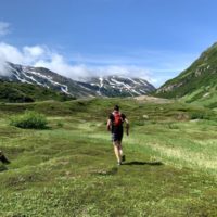
Start by taking a float plane to the remote outer coast of the Kenai Peninsula and Kachemak Bay State Park in the Gulf of Alaska and land in magnificent Taylor Bay. The run will begin at the Taylor Bay trailhead and follow the Tutka Backdoor Trail, Tutka Falls Trail, and Tutka Lagoon Trail to finish at Jakolof Bay. Total distance is 50k+, with around 9,000 feet of elevation gain spread across four major climbs. This is a run for those who want an epic experience. There is one major river crossing and three minor ones, as well as several creeks to cross, and a tidal lagoon to skirt. Parts of the route are marked only by cairns, and the trail is both steep and rugged. Most of the distance is in alpine tundra, rocks, and subalpine meadows, with lower elevation sections in old-growth spruce forest. The views are amazing. The trail is longer than any other trail in Kachemak Bay State Park, and this run is in a whole different class than any other run in the state of Alaska.


Start – Taylor Bay Trailhead to Taylor River (0-5.5 miles)
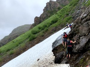
Trail climbs steeply through the forest from the Taylor Bay trailhead, popping out into alpine meadows at around a mile. Cairns mark the way through alpine tundra to a steep scree field, where the trail traverses up to Heart Lake Pass at 1,600 feet. Trail descends through alpine and subalpine meadows to the forested floor of the Taylor River Valley. Snow can linger on the steep traverse just below Heart Lake pass. Sometimes there are places folks may need to scramble around off the trail. (There were a couple short such patches in 2021 — when snowpack was quite high)
Taylor River
The Taylor is a large glacial river, and the most difficult ford on the route. Large cairns mark the best crossing point, angling upstream to end just above a tributary entrance on the far side. Rainfall or snowmelt can render the crossing hazardous. Racers should use their own judgement and consider using a stick or trekking pole for aid. It is usually crossable even on hot days, but can flood quickly in the rain. Generally it both rises and falls quickly, so rain that ends more than 24hrs before a run is unlikely to matter.
Taylor River to the High Traverse (5.5-6.5 miles)
Trail climbs steeply to follow a rocky shelf at 1,900 feet of elevation. Cairns mark the alpine portion of the route. Runners may need to cross small remnant snow patches.
High Traverse to Tutka Pass (6.5-10.5 miles)
Trail descends steeply along a rocky nose, then begins to contour the valley. After a narrow point, trail opens to a broad gravel/rock valley that climbs to Tutka Pass. This is the least-marked section, with only a few large cairns. It is also the easiest navigation — with almost no vegetation in the valley. At the head of the valley, more closely spaced cairns lead up to Tutka Pass. Snow can linger on some parts of this traverse. There is one steep snow drift that was present in both 2021 and 2022. Go uphill until the snow gets flatter, and you’ll be able to cross.
Tutka Pass to Lunch Mountain (10.5-17 miles)
A short way down the pass a nice band of tread begins on the left side of the valley. Trail descends to a broad alpine rocky valley, then traverses a boulder field at the “choke point” and opens out onto an even larger tundra valley. Cairns lead the way to a crossing of the Upper Tutka River, just above the confluence with Impossible Creek. Trail follows the right side of the valley for a while, before crossing again, and then remains on the left side thereafter. Dropping down from the Tundra Playground, trail heads through a willow-filled valley, before climbing briefly to traverse another narrow choke point. Follow rolling terrain through sub-alpine meadows to the swimming lake, then climb to Lunch Mountain.
Lunch Mountain to Tutka Bay Camp (17-20 miles)
Trail drops steeply to the river valley, crossing a small tributary that is sometimes filled with salmon. Then the trail levels out, roughly following the river valley and cutting around the tide flats, to end at the camp at the head of Tutka Bay.
Tutka Bay Camp to Sentinel Ridge (20-24 miles)
Climb again steeply, up to Sentinel Ridge at around 2000 feet. The last major climb. Sentinel Ridge is the only spot on the route with semi-reliable cell service.
Sentinel Ridge to Tutka Lagoon (24-29 miles)
Trail drops steeply, then levels out in the forest, meeting up with the old end of the Tutka Falls trail, skirting Tutka Lake and on to Tutka Lagoon Hatchery.
Tutka Hatchery to Jakolof Bay Road (29-32 miles)
Trail emerges right behind the hatchery buildings. Follow the hatchery road down to the lagoon shore, then follow the coastline around to the back of the lagoon, crossing Tutka Creek at the mouth. This is easiest if the tide is below 13 feet. If it is higher, runners will have to get wet, or bushwhack. If the tide is slightly too high, crossing the creek higher in the grass flats can help. On July 15, 2023, the tide will be below this level between 4:30PM and 11:30PM. At the back of the lagoon, a trail heads over a low forested ridge before coming out into logged areas on SNA land, where the trail will take you to the main road. The trail follows the logging road in some places, and is separated from it in a band of forest in other places. Pay close attention to flags and signage in this section.
Jakolof Bay Road to Jakolof Campsite (32-34.5 miles)
Turn right when you hit the main road. A wide mostly flat gravel road follows the shore of Jakalof Bay around 2.5 miles to the campsite near Jakolof dock.

Last-minute Bad Weather (Tutka Bay to Tutka pass and back to Jakolof) Option:
Sometimes, planes cannot fly to Taylor Bay. We cannot predict the weather very far in advance, and we don’t want it to ruin everyone’s weekend. The backup option is to water taxi to the campsite at the head of Tutka Bay and run to a turnaround point at Tutka Pass (about 10 miles), or however far you feel like going. From there, run back to the start, then over Sentinel Ridge to end at Jakolof Bay, as in the original plan. Distance remains about the same, but terrain is a bit easier.